Entebbe International Airport is the main international airport of Uganda. It is located near the town of Entebbe, on the shores of Lake Victoria, and about 35 km (21 miles) from the capital Kampala. The place were those planes remain is called the old airport. Why do they repaint abandoned planes ?


coordinates : 0°02'38.23"N 32°27'18.87"E
google map
pictures sources :
britishairtours
fabry michael
text source :
wikipedia

Neon Museum at the Fremont Street Experience in Las Vegas, Nevada, United States, features signs from old casinos and other businesses displayed outdoors.
For many years, the Young Electric Sign Company stored many of these old signs in their "boneyard." The signs were slowly being destroyed by exposure to the elements. The museum is slowly restoring the signs and placing them around the Fremont Street Experience.


coordinates : 36°10'38.45"N 115°08'04.06"W
google map
pictures sources :
Abby A.
alienated
text source :
wikipedia
Artificial Owl recommends:

Read more [+]

Rhyolite, Nevada is a ghost town in Nye County, Nevada, United States. It is located in the Bullfrog Hills, about 3.8 miles west of the town of Beatty, near the eastern edge of Death Valley.
The town came into existence as the result of a gold rush that began in 1904, and had its peak population from 1905 to 1910, when decreased gold production led to a decline that culminated in its abandonment by 1919.
Gold was discovered in the area by Shorty Harris and E.L. Cross on August 4, 1904. Their "Bullfrog strike" gave rise to a number of gold rush towns that drew prospectors and speculators from surrounding towns such as Goldfield and Tonopah. Rhyolite, named for the deposits of the rock which contained much of the gold, would become the largest of these settlements.
The most important operation was the Montgomery Shoshone mine and a mill was constructed to process its ore. The mine was sold to industrialist Charles M. Schwab in 1906 for a reported 5 million dollars. By 1907, the town had electricity with an estimated population of 3,500 to 10,000. The Panic of 1907 is believed to have adversely affected the town's economy.
Production began to slow down by 1908 and the mine and mill were closed in 1911. By 1910 only an estimated 675 people remained in Rhyolite. The lights and power were turned off in 1916. By 1919, the post office had closed and the town was abandoned.
The Bottle House, a house built from thousands of beer and liquor bottles by Tom Kelly in 1906, was restored by Paramount Pictures in 1925 for use in a movie. Recently rebuilt, it remains standing and complete.
coordinates : 36°54'10.06"N 116°49'43.02"W
google map
pictures sources :
TrekkinD
pbt1322
Bill Cook
Nicolas
jgebis
Jan van Wijk
wikipedia
text source :
wikipedia
Artificial Owl recommends:

Read more [+]

Murmansk Russian Sverdlov class cruiser built 1955 one of the last all gun cruisers decommitioned 1987 scrapped 1995 Lost 1994 while in tow to India for scrap along the berents coast between North cape and Tromso is now aground on Soeroey Finmark.


coordinates : 70°38'8.58"N 21°57'23.46"E
google map
pictures sources :
rickydiver78
divenorway
hugsvend
text source :
divenorway
Read more [+]

Uyuni is a town in the Potosí Department in the south of Bolivia. Founded in 1890 as a trading post, the town has a population of 10,600. The town's primary function is as a gateway for tourists visiting the world's largest salt flats - the Salar de Uyuni.
It is an important transport hub, being the location of a major railway junction. Four lines join here, respectively from La Paz (via Oruro), Calama (in Chile), Potosí, and Villazón (on the Argentinean border, where the line now ends).
One of the sights in Uyuni is the train cemetery - filled with old, rusting steam locomotives.


coordinates : 20°28'36.98"S 66°49'59.07"W
google map
pictures sources :
Frank Gräber
briver
Schiøtz
eamonncy
text source :
wikipedia
Read more [+]
Shipwreck of the Semiramis near Vori beach, Andros island, Greece
| .Greece, Shipwreck | 0 comments »
I have no more information about this ship, the remains look beautiful though. Thanks to the desertic surrounding, it looks like a mysterious ghost. Let me know in the comments if you know anything about it.


coordinates : 37°54'05.69"N 24°52'56.15"E
google map
pictures sources :
Mark-x
John St. John
spyrosfly
cosd
Read more [+]

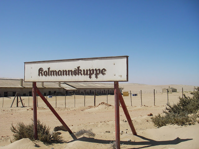
Kolmanskop is a ghost town in southern Namibia, a few kilometres inland from the port of Lüderitz. It was a small mining village and is now a popular tourist destination run by the joint firm NAMDEB (Namibia-De Beers).
It developed after the discovery of diamonds in the area in 1908, to provide shelter for workers from the harsh environment of the Namib Desert. The village was built like a German town, with facilities like a hospital, ballroom, power station, school, skittle-alley, theater and sport-hall, casino, ice factory and the first x-ray-station in southern Africa. It also had a railway line to Lüderitz.
The town declined after World War I as diamond prices crashed, and operations moved to Oranjemund. It was abandoned in 1956 but has since been partly restored. The geological forces of the desert mean that tourists can now walk through houses knee-deep in sand.


coordinates : 26°42'11.79"S 15°13'52.18"E
google map
pictures sources :
wikipedia
zapata
martijnverdonk
Jordi Boshoven
delpha
Okkert Brits
text source :
wikipedia
Artificial Owl recommends:


